

Namib-Naukluft Park
In a way it’s refreshing when a wonderful little sanctuary remains beyond our hunger for leisure destinations. While Naute’s tourism potential remains unrealised, the game park does fulfil its conservation function.
In a way it’s refreshing when a wonderful little sanctuary remains beyond our hunger for leisure destinations. While Naute’s tourism potential remains unrealised, the game park does fulfil its conservation function. It protects attractive Nama Karoo landscapes and a variety of wildlife and desert flora. It’s a characteristic sample of Namibia’s arid southern reaches, diversified by the large waterbody. Those who have access to the park through their work are privileged.
Read More
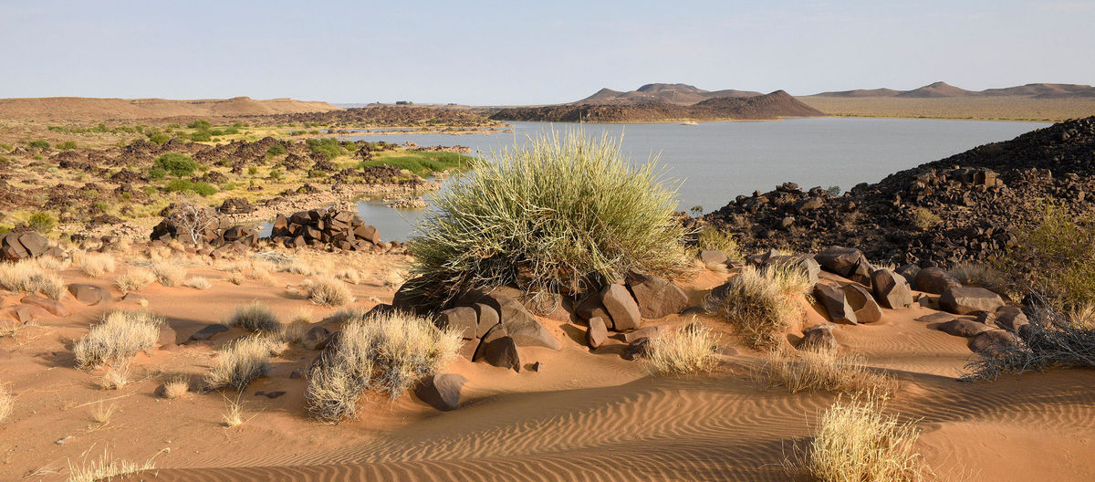
Naute is one of Namibia’s largest man-made lakes. Its shoreline, abutting long stretches of rocky plains and intricate sections of small bays, is very attractive The dam location on the Löwen River was already identified by German engineers over a century ago, yet construction of the reservoir only took place 70 years later. The dam was created as a reliable source of water for the nearby town of Keetmanshoop, and to enable an agricultural scheme adjacent to the reservoir.
The lake creates an ideal focal point for a game park, although this was only proclaimed just prior to independence. Thirty years on, its tourism potential remains untapped, overlooked in the vastness of the ‘forgotten South’. Discussions around a tourism concession with the neighbouring !Gawachab Conservancy may gain momentum in the future. For now, Naute is still worth a brief stop-over visit while travelling between Keetmanshoop and the Fish River Canyon.
WHEN TO BE THERE:
- Visitor access is restricted to the recreation area; this is open all year
- Day temperatures can be very hot during summer
- Fishing competitions are held intermittently & the recreation area is a weekend retreat for locals
- The game park is currently not open to visitors
WHAT TO DO:
- Stop at the lake for a refreshing break on your travels
- Enjoy a short walk & some good birding
- Do a spot fishing along the shore
- Visit the nearby agricultural scheme
WHAT TO REMEMBER:
- Access is restricted to the small recreation area
- A permit is required for fishing, obtainable at the Karas Regional Council in Keetmanshoop
- There are no amenities at the dam
- Do not litter, take all rubbish with you
History
Even when southwestern Africa was barely populated, and enough resources were apparently available for all, the Namib Sand Sea drew people to it. When Europeans arrived, they heard rumours of people living in the dunes – conjuring up visions of hidden oases, of a ‘Bushman Paradise’. Such dreams have long been dispelled. Every square metre of the Namib has been captured on satellite imagery. Yet the allure of the near-impenetrable dune sea remains – now accessible through four-by-four adventures.
The most comprehensive precolonial map of the areas then known as Great Namaqualand and Damaraland was drawn by the German missionary, trader and explorer, Johannes Theophilus Hahn, in 1879. It covered the area from the !Gariep River (today’s Orange River) as far north as the ‘Uni!ab River (Uniab) and the Omuramba ua Matako (Omatako). The bold label ‘Great Namaqualand’ reaches from Walewich Bay (Walvis Bay) to the ‘Ê»Karas Mountains. The map includes astounding details of rivers and watercourses, mountains and hills, settlements and water points with all their names, as well as numerous notes on inhabitants and chiefs. It is crammed with information across much of the area between the !Gariep and Tsoaxoub (Swakop) rivers, with detail rapidly decreasing northward.
The Namib Sand Sea is a basically blank space on the map, with two intriguing exceptions. ‘Sandy Desert inhabited by wandering Bushmen called !Geinin; Abundance of Ostriches & Gemsbucks’ is written in three well-spaced lines covering much of the sand sea. The second inscription is more intriguing still, and inspired many expeditions into the erg. East of Conception Bay and south of the !Khuiseb River (Kuiseb) there is a lengthy note in small handwriting: ‘Hereabouts are said to be some large fountains inhabited by an independent Namaqua Tribe. Abundance of Game. Lions, Camelopards [giraffes], Rhinoceros, Elands, Ostriches.’ This became the fabled ‘Bushman Paradise’, which fuelled the imagination of explorers and fortune-seekers for decades. Officers of the German Schutztruppe were foremost amongst them.
In 1909, Officer Märker was one of the first Europeans to explore the dunes westwards along the Tsondab River in the hope of finding the legendary fountains. He had driven part of the way from Windhoek in one of the first vehicles imported into the colony, and then rode into the dunes on camelback. He managed to come to within about 20 kilometres of coast – without finding any water or people.
Also in 1909, Officer Walter Trenk and company used camels to explore the course of the Tsauchab River and reached Sossusvlei. During a second expedition in mid-1909, Trenk traversed the dune sea to reach St Francis Bay, then travelled north via Meob Bay to near Conception Bay, and back inland along the 24th latitude to the Naukluft. The camelback journey covered over 500 kilometres (around 300 of them across high dunes!) in 16 days – a truly astounding feat.
Trenk wrote of a prospector already having crossed the sand sea from the Tsauchab to the coast prior to his own expedition. He also notes a completely trampled ‘street’ running along the coast, which he followed between Meob Bay and Conception Bay. During only six days spent along the Atlantic, Trenk met a police patrol, prospectors and a trader and their respective parties, as well as ‘bushmen’ living near Meob Bay. Obviously, the coastal route between Lüderitzbucht (Lüderitz) and Walfischbucht (Walvis Bay) was much used at this time, and local people still lived along the coast in this area.
The surveyor Maack, stationed at Conception Bay during 1912, mentions that the search for the ‘Bushman Paradise’ – and related hopes of diamonds or other riches – was still very much alive in the minds of many fortune-hunters at this time.
The sand sea is not an easy place for archaeological research. Even with modern equipment it remains difficult to work in. Potential sites have mostly been obliterated by the sand, although some may briefly be uncovered by the wind, soon to be swallowed again by shifting sands. Our knowledge of the more-distant past in the sand sea remains very limited, yet enough evidence has been found to show that people used the area, at least sporadically, for hundreds of thousands of years.
The sand sea is littered with more-recent signs of man – mostly abandoned mining sites with intriguing names that whisper of adventures past: Charlottenfelder, Fischersbrunn, Grillenberger, Holsatia. The sites are today of tourism interest and some lie along the routes now used by safari operators. The coast offers additional intriguing relics here. Famous shipwrecks such as the Otavi at Spencer Bay and the Eduard Bohlen south of Conception Bay can be visited as part of a sand sea safari. The Eduard Bohlen ran aground in 1909, but now lies over 350 metres inland from the seashore, highlighting rapid changes to the shoreline.
Life in, and exploration of, the dune sea was always dictated by water availability. A surprising number of freshwater springs are located along the coast, and water can be found along the ephemeral rivers in the east. Sesriem Canyon was once an important water source, which lead to its name. Sesriem means ‘six thongs’ – six leather thongs from a wagon harness were tied together to collect water from a waterhole in the canyon by lowering a bucket from the canyon’s edge. Blanketed as it is by hundreds of metres of sand, the dune sea itself is devoid of fresh water.
The name Namib-Naukluft naturally evolved as the park was expanded to include both areas. ‘Namib’ is a Nama word meaning ‘desert’ and ‘naukluft’ is an adaptation of the Afrikaans words ‘nou kloof’, meaning ‘narrow gorge’.
Activities
Conservations
Deserts are places of silence, quiet contemplation and solitude. In the early 1990s, it was still possible to be at Sossusvlei without other visitors. An incredible privilege, to stand in that scenery alone, or with just one or two like-minded companions. Today, Sossusvlei is rightfully one of the most iconic attractions of Africa. Yet it highlights that dilemma of tourism: We all long to experience the pristine, the unique and the magical, and thereby congest – and mar – some of the greatest sites on Earth.
Tourism is continually confronted with a fundamental challenge: making unique and often very sensitive attractions accessible without major negative impacts on those attractions. ‘Overtourism’ and ‘touristification’ are being discussed as pertinent issues around the world, as rapidly growing visitor numbers at key sites put increasing pressure on those sites. Impacts include not only direct physical damage and threats to biodiversity, but also cultural and social disruption of communities, steep price increases that exclude locals, overcrowding and a loss of the character and sense of place of an area. Modern conservation seeks to safeguard environments while at the same time justifying their status as protected areas through revenue generation that benefits local communities and the country as a whole. These seeming dichotomies can be reconciled, but only with vision and careful, sensitive management.
At Sossusvlei, the direct, physical impacts of thousands of people can be managed by cordoning off sensitive areas and creating wooden walkways and viewing platforms to reduce the already very noticeable effects of trampling on desert vegetation, ancient tree skeletons and sensitive clay deposits. Tourism pressure can also be diffused by diverting focus to a broader range of stunning sites in the area.
The outstanding value of the Namib Sand Sea led to its listing as a UNESCO World Heritage Site in 2013. The site easily meets the criteria for natural heritage site selection – ‘exceptional natural beauty’, ‘significant on-going geological processes’, ‘significant on-going ecological and biological processes’ and ‘significant natural habitats for the conservation of biological diversity’. Although they are overshadowed by its scenic attributes, the sand sea also holds important archaeological and palaeontological sites. This is the only coastal desert that features vast, contiguous dune fields, which create a unique environment for all living organisms, including humans and their ancestors.
Map
-24.26560 16.23920
Gondwana Collection Namibia (Pty) Ltd t/a Gondwana Travel Centre
2nd floor, Ardeco Building, Nelson Mandela Avenue (entrance Bassingthwaighte St.)
Klein Windhoek
Klein Windhoek
Contacts
info@namibian.org