

Bwabwata National Park
In a way it’s refreshing when a wonderful little sanctuary remains beyond our hunger for leisure destinations. While Naute’s tourism potential remains unrealised, the game park does fulfil its conservation function.
In a way it’s refreshing when a wonderful little sanctuary remains beyond our hunger for leisure destinations. While Naute’s tourism potential remains unrealised, the game park does fulfil its conservation function. It protects attractive Nama Karoo landscapes and a variety of wildlife and desert flora. It’s a characteristic sample of Namibia’s arid southern reaches, diversified by the large waterbody. Those who have access to the park through their work are privileged.
Read More
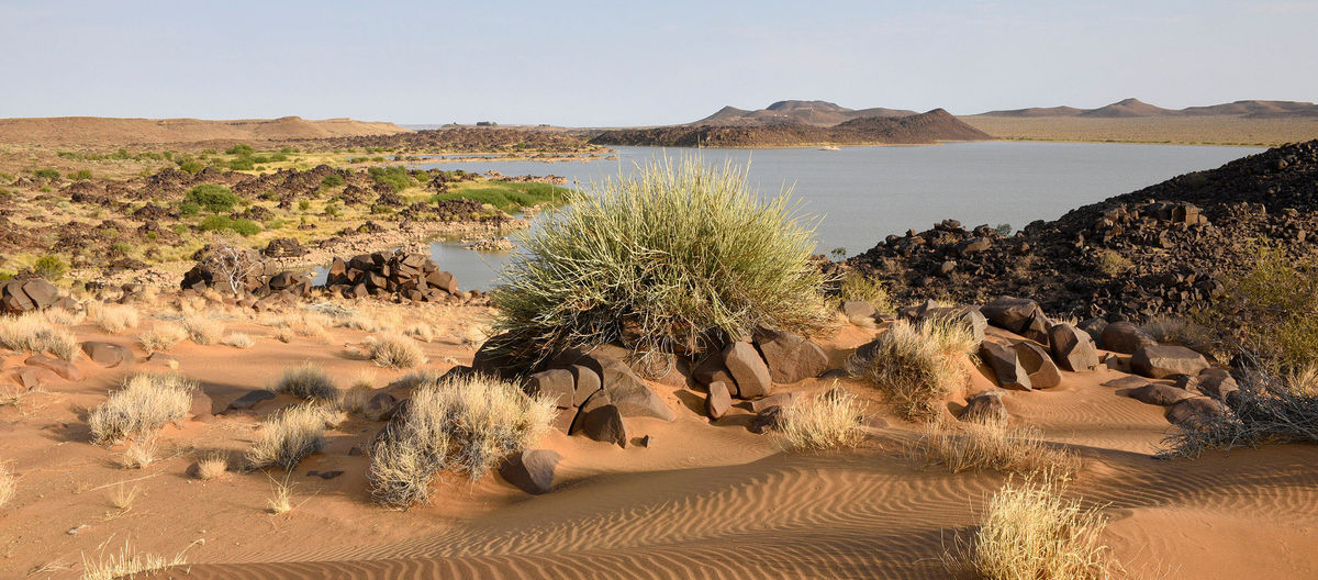
Naute is one of Namibia’s largest man-made lakes. Its shoreline, abutting long stretches of rocky plains and intricate sections of small bays, is very attractive The dam location on the Löwen River was already identified by German engineers over a century ago, yet construction of the reservoir only took place 70 years later. The dam was created as a reliable source of water for the nearby town of Keetmanshoop, and to enable an agricultural scheme adjacent to the reservoir.
The lake creates an ideal focal point for a game park, although this was only proclaimed just prior to independence. Thirty years on, its tourism potential remains untapped, overlooked in the vastness of the ‘forgotten South’. Discussions around a tourism concession with the neighbouring !Gawachab Conservancy may gain momentum in the future. For now, Naute is still worth a brief stop-over visit while travelling between Keetmanshoop and the Fish River Canyon.
WHEN TO BE THERE:
- Visitor access is restricted to the recreation area; this is open all year
- Day temperatures can be very hot during summer
- Fishing competitions are held intermittently & the recreation area is a weekend retreat for locals
- The game park is currently not open to visitors
WHAT TO DO:
- Stop at the lake for a refreshing break on your travels
- Enjoy a short walk & some good birding
- Do a spot fishing along the shore
- Visit the nearby agricultural scheme
WHAT TO REMEMBER:
- Access is restricted to the small recreation area
- A permit is required for fishing, obtainable at the Karas Regional Council in Keetmanshoop
- There are no amenities at the dam
- Do not litter, take all rubbish with you
History
Matambo Singwangwa embodies the complexity of conservation and local communities in Namibia’s far northeast. Born in Bwabwata, he spent his childhood in the bush, growing into the hunter-gatherer life of his Baraquena parents. As a teenager, he was forced to join the South African army. With independence, he was employed by Namibia’s fledgeling environmental ministry and could apply his natural knowledge and skills in positive ways. Matambo has worked tirelessly to curb poaching, promote conservation and rebuild wildlife populations. He’s still out in the field for MET today, fighting for conservation.
The Namibian Kalahari is mostly devoid of hills, even rocks. The spectacular rock art and related archaeology found across much of the western half of the country is absent here. As a result, less archaeological work has been done in the Kalahari. Although people and their prehistoric relatives are likely to have utilised the higher-yielding northern Kalahari – and especially its perennial rivers – more than the country’s arid west, their relics are patchy. The little evidence that has been uncovered confirms tens of thousands of years of human presence here, and a growing trade in beads and other goods for at least half a millennium.
The oral history of the area goes back hundreds of years and portrays the immigration from the north of various groups speaking Bantu languages. Perpetual power struggles ensued, dominated by successive kingdoms of the Kololo and Lozi from the 1600s until well into the early twentieth century. By this time, the Tswana Empire was encroaching from the south. The regency of the powerful regimes affected all other groups, including the Kwangali, Mbunza, Shambyu, Gciriku and Mbukushu from the Okavango and the Subiya, Fwe and Yeyi living between the Kwando and Zambezi rivers. SiLozi became the lingua franca of the region during the last Lozi reign, and remains the most widespread language besides English in the Zambezi Region today.
The San, the earliest known inhabitants of the northern Kalahari, were displaced by the immigration of Bantu communities. A San group called the Khwe made the land between the Okavango and Kwando their realm. The area thus became known as the ‘Hukweveld’. Like other San communities, the Khwe are known by various names including Kxoé, Barrakwenge and Baraquena.
The Caprivi Strip became a perpetual frontier the day its peculiar borders were created. Colonial borders generally ignored indigenous land distribution and use, but few are more striking in their disregard for anything that might have existed before than the parallel lines drawn between the Okavango and Kwando rivers to give German South West Africa a wedge into the African interior, a potential thoroughfare to East Africa and access to the mighty Zambezi River.
The strip was defined through two treaties, one between Germany and Portugal (1886) to delineate the border with Angola, and the other between Britain and Germany (1890) to confirm the border with British Bechuanaland. Both borders remained disputed during the German colonial period, due mainly to a lack of on-the-ground knowledge of the area. They were finalised after World War I, when South Africa was given a mandate by the United Nations to administer South West Africa. The area is still widely referred to as the Caprivi, although today it encompasses the Zambezi Region and a part of the Kavango East Region.
During the ‘scramble for Africa’ by European powers, the desert lands between the Kunene and Orange rivers were amongst the last to be claimed, and the swamps of the Okavango, Kwando and Zambezi were amongst the final reaches to be explored. These areas were difficult to traverse, infested with tsetse fly and plagued with malaria. The early explorers who penetrated here struggled through endless swamps and suffered from regular bouts of fever.
David Livingstone, the first European known to have reached what is today the Zambezi Region, explored the area in the early 1850s. Karl Johan Andersson, searching for the source of the Kunene River, was the first European to reach, and name, the Okavango in 1859. Andersson was apparently also the first to use the term South West Africa.
The Caprivi was generally neglected by both the German and South African governments – until apartheid South Africa turned the strip into the main front in its struggle to deny Namibia independence. Over a period of several decades from the mid-1930s, West Caprivi was proclaimed a livestock-free area, then a game park and finally a restricted military zone. From the 1970s, half a dozen military bases were created between the Okavango and Kwando, and further to the east.
The heavy military presence, and the armed conflict that ensued, had a massive impact on people and the environment. The Khwe, as well as several thousand !Xun (also called !Kung) who fled here in the 1970s during Angola’s civil war, were allowed to stay in the strip for strategic reasons. Many men were recruited into the South African army for their skills as trackers and scouts. The dependency that developed left the San disempowered minorities. Since independence, inclusive policies have enabled the Khwe to benefit from the park and its resources; they still make up the majority of residents living in Bwabwata today, while most !Xun have left.
The physical scars of Namibia’s struggle for independence are healing. Wildlife has returned, and remnants of the military occupation slowly crumble into the vegetation. Yet the people of today’s Zambezi Region continue to strive for an own identity. In 1999, an uncoordinated attempt by a group called the Caprivi Liberation Movement to secede the area as an independent republic was quashed by the Namibian government. The region is now receiving significant development attention, but at the furthest extremity from the Namibian capital, some people still feel disenfranchised by history.
Activities
Conservations
I drove through Caprivi for the first time soon after Namibia’s independence. I’d worked a short stint as an assistant designer for the United Nations Transition Assistance Group, UNTAG, and had gained insights into Namibia’s precarious path to nationhood. I was using my first earnings to show friends ‘my new country’. ‘The Strip’ had the atmosphere of a military frontier; no longer a war zone, exactly, but still raw from decades of conflict and suppression. The recently proclaimed national parks were unknown. I don’t remember seeing notable wildlife until we crossed into the Chobe National Park in Botswana.
To see a female bushbuck and her calf feeding quietly amongst the toppled gravestones of a war cemetery in Bwabwata today is a strangely eerie sight, yet one that is symbolic of regeneration – a healing of scars. Healthy game numbers and tranquil animals are certainly an amazing change from the turmoil of earlier times.
West Caprivi was recognised by the South African administration as the traditional land of the Khwe in the 1930s, but was declared a livestock-free zone in 1937. Only the Khwe were considered eligible residents and Mbukushu groups that had settled on the west bank of the Kwando were relocated with their livestock in 1940. In 1964, the infamous Odendaal Commission, created to design separate homelands for all non-White ethnic groups in Namibia, recommended that the West Caprivi should become a designated homeland for the Khwe.
The administration did not follow Odendaal’s suggestion, having already proclaimed the area as the West Caprivi Nature Park in 1963. This was instead upgraded to the status of Caprivi Game Park in 1968. However, recommendations of a 1966 ecological survey to resettle all park residents and create an exclusive conservation area were not implemented either.
In light of the political climate of the time, the suggestion that the park was created mainly to provide apartheid-era South Africa with a broad military front against perceived threats seems well founded. The Angolan liberation war had begun in 1962, independence was imminent for Botswana and for Zambia, and Namibia’s own struggle for sovereignty was gaining momentum. By the early 1970s, Namibia’s endeavours had turned into an armed conflict and the strip became a restricted military zone dotted with army bases.
Staff of the Department of Nature Conservation were excluded from Caprivi Game Park and conservation responsibilities were taken on by the army. The general discord that followed included heavy poaching. The South African army was later shown to have been involved in dealing with ivory and rhino horn, while locals poached to sell meat or supply their own households.
To conservationists, the importance of conserving the Okavango riverfront as vital wildlife habitat had become evident in the early 1980s, and the Department of Nature Conservation began negotiations with the Administration for Kavango, leading to a memorandum of agreement in 1982 and the proclamation of the Mahango and Popa Falls game parks in ’89.
After independence, a more inclusive approach to conservation motivated a comprehensive socio-ecological survey of West Caprivi, completed in 1994. Extensive consultation with local people during the survey laid the groundwork for community involvement in protected areas, and Namibia’s community conservation approaches in general. The survey report made a variety of recommendations, such as zoning the park for different uses to enable the Khwe, Mbukushu and !Xun to continue living in the park – and to benefit from its resources through the use of veld foods and income generated from conservation-hunting concessions.
The survey also highlighted the pressing need to conserve what was seen as one of the most important conservation areas in Namibia, then known as the Golden Triangle – the wedge of land between the Caprivi Game Park and the Kwando River, which is part of today’s Kwando Core Area.
In line with the registration of numerous conservancies in Caprivi and elsewhere around Namibia, the people living in the Caprivi Game Park formed the Kyaramacan Association in 2005 to represent their interests through a similar structure to communal conservancies. The association was officially recognised by the MET the following year.
An evaluation of the coverage of state-protected areas around Namibia at the turn of the millennium motivated plans to redefine the status and cover of some of the country’s parks. Including many of the recommendations of the 1994 survey report, Bwabwata National Park was proclaimed in 2007 and encompassed both the Mahango Game Park and the Golden Triangle.
The return of wildlife to the park was boosted by translocations of small numbers of key species. Now a multitude of wildlife can once again be seen along the rivers and floodplains, and in the adjacent woodlands of Bwabwata.
Bwabwata is in many ways a model park, where modern, inclusive conservation approaches seek to balance the needs of rural communities with those of the environment. The wildlife has returned, habitats are being restored and park residents are reaping some of the benefits. Yet the balance is a precarious one. Escalating ivory poaching has had an impact on Bwabwata, motivating the government to install a semi-permanent police and military presence in the park. This has restricted the freedom of movement of residents – and of visitors – but has curtailed the poaching.
Conservation of a complex park such as Bwabwata has numerous facets, which can be hard for visitors to realise. The thin, long park falls into two administrative regions, Kavango East and Zambezi. It is dissected by a national road that connects the regional capitals Rundu and Katima Mulilo. It is bordered by different nations north and south. It has thousands of people living in the middle and more on either side … seemingly a recipe for some of the greatest conservation challenges any park can face.
The combination of the Zambezi Region’s large elephant population and its location wedged between four countries turn it into a prime target for poaching and trafficking. As the illegal ivory trade escalates across Africa, impacts on Bwabwata are inevitable, but proactive law enforcement at various levels is reaping results. Constant police and military surveillance might not be ideal for tourism, but it is reducing the impacts of poaching.
Around 5,500 people live in the multiple-use area of Bwabwata, with Mushashane and Mutc’iku along the Okavango, Omega I and Chetto in the centre of the park and Omega III and Mashambo near the Kwando Core Area being the main settlements. Khwe comprise more than three-quarters of the population. Mbukushu and a few !Xun make up the remainder, although a growing influx of settlers from west of the park is changing these population dynamics. The multiple-use area makes up about 70 per cent of the park.
The interests of most of these residents are represented through the Kyaramacan Association. A joint technical committee advises on development of settlements and infrastructure, and on livestock management and other issues. Although their movements within the park are currently restricted, people generally have a variety of rights and benefits from the park. The use of local plant resources and veld food forms an important component. The two conservation-hunting concessions in the park are amongst the best hunting areas in the country and the benefits they generate are significant.
These conservation merits are vital in offsetting the costs of living in the park for the people, such as limited access to agricultural land, impacts on fields by large herbivores and on livestock by predators – and an occasional threat to human life from a dangerous wild animal.
That wildlife populations have been effectively rebuilt in such a problematic park is proof of what can be achieved through innovative conservation approaches. Early European explorers, while recording abundant game in what are now Bwabwata and the eastern Zambezi Region, already noted that it was in decline.
Elephants were quickly decimated and displaced by ivory hunters, and the cumbersome white rhino was the first large animal to disappear entirely from the region by the late 1800s. The smaller, more skittish black rhino survived for another century and a half in the woodlands of Bwabwata. It was still reported as common along the Kwando in the 1960s and rumours of sightings persisted into the early 1990s. Both rhinos are now locally extinct in northeastern Namibia and, unless real solutions to the rhino crisis can be found, are unlikely to be returned.
Oribi, a small antelope similar to the steenbok, were recorded in Bwabwata in the 1960s and were still present in Mahango and probably along some parts of the Kwando into the ‘80s, but are now considered locally extinct. Besides rhinos, they are the only larger wildlife that have not returned to the area.
Crocodiles were reported as wiped out along the Kwando and rare in the Okavango by the mid-1960s, but are now common again in the protected stretches of both rivers. Sable were at one stage locally extinct in Mahango, but have been reintroduced. An exchange of wildlife with Botswana in 2008 brought waterbuck and tsessebe to Mahango and black rhino from Etosha to Botswana.
Today Bwabwata is the most important park for the protection of Namibia’s elephant population. Over a third of the 22,000 elephants estimated for Namibia roam across the park. Bwabwata is similarly important for the conservation of many other species, with wild dog, sable, tsessebe and roan foremost amongst them.
The value of Bwabwata’s birdlife is recognised through the designation of the Bwabwata–Okavango Ramsar Site, and Mahango is additionally listed as an internationally Important Bird and Biodiversity Area.
Effective fire management is crucial for the long-term conservation of Bwabwata’s woodlands. Fires are set by people to clear vegetation prior to the planting season each year. They are rarely controlled and regularly burn large parts of the park. This has a big impact on its vegetation, especially on large old trees that are being slowly killed by an annual succession of fire scars.
Map
-18.07690 21.54090
Gondwana Collection Namibia (Pty) Ltd t/a Gondwana Travel Centre
2nd floor, Ardeco Building, Nelson Mandela Avenue (entrance Bassingthwaighte St.)
Klein Windhoek
Klein Windhoek
Contacts
info@namibian.org